1912 Map of Kimmswick
USGS Topo · Published 1912About this map
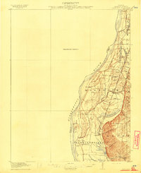
The Mississippi River floodplain dominates this landscape, where the flat alluvial bottoms of Moredock and New Hanover meet the dramatic rise of the Bluff. Surveyed in 1910, the map illustrates an era of riverfront reliance and rail expansion, centered around the commerce at Harrisonville and its associated Harrisonville Landing. Transportation through the bottomlands was anchored by the St Louis Iron Mountain and Southern railroad, which skirts the base of the eastern heights. A network of rural institutions, including Blue Church and numerous local schoolhouses like Miles Prairie School and Sculloms School, reveal a densely settled agricultural community. Significant water features such as Moredock Lake and Long Slash suggest the complex hydrology of the area before modern levee systems extensively altered the natural drainage and wetland patterns of the basin.
Find a feature on this map
35 named features on this map. Tap any name to fly to it.
Don’t see what you’re looking for? This feature index may not catch every label — zoom into the map to look around manually.
Map Details
Editions of this 1912 Kimmswick Map
2 editions found
Other maps of this area

1888 · St. Louis
USGS Topo · 1:62,500

1901 · De Soto
USGS Topo · 1:125,000

1903 · O'Fallon
USGS Topo · 1:125,000

1910 · Waterloo
USGS Topo · 1:62,500

1912 · Kimmswick
USGS Topo · 1:62,500

1913 · Waterloo
USGS Topo · 1:62,500

1915 · Renault
USGS Topo · 1:62,500

1915 · Crystal City
USGS Topo · 1:62,500

1916 · Kimmswick
USGS Topo · 1:62,500

1930 · De Soto NE
USGS Topo · 1:24,000