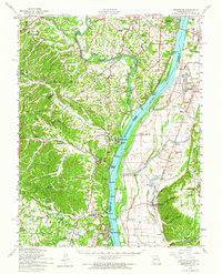
1954 Map of Kimmswick
USGS Topo · Published 1964About this map
The Mississippi River serves as the central artery for this mid-century landscape, where the borders of St. Louis, Jefferson, and Monroe Counties converge. At the northern edge, the expansive Jefferson Barracks military installation overlooks the river near Cliff Cave, while the southern reaches are defined by the industrial presence of Herculaneum. The map illustrates a transition from the developing residential communities of Arnold, Le May, and Oakville to the agricultural bottoms near Valmeyer and Harrisonville. Local connectivity is highlighted by the Missouri Pacific railroad and the ST Louis-San Francisco line, which parallel the riverbanks. For genealogists, the map is particularly detailed, identifying numerous local landmarks like Nazareth Convent, Mahlers Cem, and Combs Sandy Ch Cem. The topography is marked by significant drainages such as Joachim Creek and Meramec River, alongside distinct features like Potato Hill and the river-bound Chesley Island.
Find a feature on this map
109 named features on this map. Tap any name to fly to it.
Don’t see what you’re looking for? This feature index may not catch every label — zoom into the map to look around manually.
Map Details
Editions of this 1954 Kimmswick Map
2 editions found
Other maps of this area

1888 · St. Louis
USGS Topo · 1:62,500

1901 · De Soto
USGS Topo · 1:125,000

1903 · O'Fallon
USGS Topo · 1:125,000

1910 · Waterloo
USGS Topo · 1:62,500

1912 · Kimmswick
USGS Topo · 1:62,500

1913 · Waterloo
USGS Topo · 1:62,500

1915 · Renault
USGS Topo · 1:62,500

1915 · Crystal City
USGS Topo · 1:62,500

1916 · Kimmswick
USGS Topo · 1:62,500

1930 · De Soto NE
USGS Topo · 1:24,000