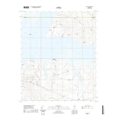
2020 Map of Kincaid
USGS Topo · Published 2020About this map
Grenada Lake dominates the central landscape of this northern Mississippi survey, where the water's edge carves a complex shoreline against the rising terrain of Crescent Ridge and Little Mtn. The map documents a transition between the recreation-focused areas near Old Orchard Bay and the more established rural settlements like Kincaid and Choctaw. Evidence of early road networks and rural land divisions is visible through labels like Old Hwy 8 and the grid of county roads that service local cemeteries such as Browns Cem. The drainage patterns are clearly defined by Knight Creek, Redgrass Creek, and Hurricane Br, which feed into the primary reservoir. This modern topographic record reflects the ongoing intersection of water management, forest conservation, and the enduring small-town geography of Grenada Co.
Find a feature on this map
58 named features on this map. Tap any name to fly to it.
Don’t see what you’re looking for? This feature index may not catch every label — zoom into the map to look around manually.
Map Details
Editions of this 2020 Kincaid Map
This is the sole edition of this map. No revisions or reprints were ever made.
Other maps of this area

1953 · West Point
USGS Topo · 1:250,000

1954 · Grenada
USGS Topo · 1:62,500

1954 · Duck Hill
USGS Topo · 1:62,500

1954 · McCarley
USGS Topo · 1:62,500

1955 · Coffeeville
USGS Topo · 1:62,500

1958 · West Point
USGS Topo · 1:250,000

1963 · West Point
USGS Topo · 1:250,000
1971 · Coffeeville
USGS Topo · 1:24,000
1983 · Tie Plant
USGS Topo · 1:24,000
1983 · Duck Hill
USGS Topo · 1:24,000