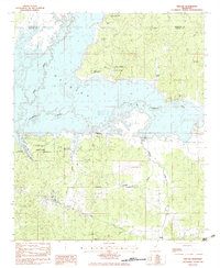
1983 Map of Kincaid
USGS Topo · Published 1984About this map
Grenada Lake dominates this northern Mississippi landscape, where the confluence of the Skuna River and Yalobusha River creates a sprawling reservoir across the border of Yalobusha and Grenada counties. The map captures the extensive recreational development around the water, including Carver Point State Park and Hugh White State Park, alongside numerous public use areas like Choctaw and Skuna-Turkey Creek.
Find a feature on this map
27 named features on this map. Tap any name to fly to it.
Don’t see what you’re looking for? This feature index may not catch every label — zoom into the map to look around manually.
Map Details
Editions of this 1983 Kincaid Map
This is the sole edition of this map. No revisions or reprints were ever made.
Other maps of this area

1953 · West Point
USGS Topo · 1:250,000

1954 · Grenada
USGS Topo · 1:62,500

1954 · Duck Hill
USGS Topo · 1:62,500

1954 · McCarley
USGS Topo · 1:62,500

1955 · Coffeeville
USGS Topo · 1:62,500

1958 · West Point
USGS Topo · 1:250,000

1963 · West Point
USGS Topo · 1:250,000
1971 · Coffeeville
USGS Topo · 1:24,000
1983 · Tie Plant
USGS Topo · 1:24,000
1983 · Duck Hill
USGS Topo · 1:24,000