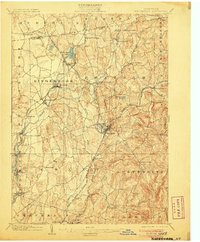
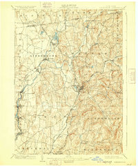
1903 Map of Kinderhook
USGS Topo · Published 1906About this map
Kinderhook Creek serves as the central artery for this portion of Columbia County, driving the early industrial development of riverside settlements like Valatie and Stuyvesant Falls. At the turn of the century, the landscape is defined by its complex transportation network, where the Boston and Albany R. R. and the Rutland R. R. converge at Chatham, a vital rail hub for the region. The map reveals a dense pattern of hamlet life, from the lakeside community of Niverville near Kinderhook Lake to the mill-driven economy at White Mills. Moving south, the terrain shifts into the higher elevations of Austerlitz and Hillsdale, where smaller villages like Spencertown and Harlemville are situated among the winding courses of the Kline Kill and Pulsit Kill. This survey captures the county just as the Hudson and Chatham Br. railroad connected these diverse agricultural and manufacturing centers.
Find a feature on this map
57 named features on this map. Tap any name to fly to it.
Don’t see what you’re looking for? This feature index may not catch every label — zoom into the map to look around manually.
Map Details
Editions of this 1903 Kinderhook Map
6 editions found

Other maps of this area

1885 · Sheffield
USGS Topo · 1:62,500

1888 · Sheffield
USGS Topo · 1:62,500

1888 · Berlin
USGS Topo · 1:62,500

1888 · Pittsfield
USGS Topo · 1:62,500

1890 · Pittsfield
USGS Topo · 1:62,500

1890 · Berlin
USGS Topo · 1:62,500

1891 · Sheffield
USGS Topo · 1:62,500

1893 · Troy
USGS Topo · 1:62,500

1893 · Coxsackie
USGS Topo · 1:62,500

1893 · Sheffield
USGS Topo · 1:62,500