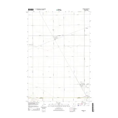
2014 Map of Kindred
USGS Topo · Published 2014About this map
Kindred serves as the primary hub in this portion of the Red River Valley, situated at the southeastern corner of the map where the Sheyenne River cuts through the landscape. The town's residential street grid is well-established, featuring names like Elm St and Dakota St, while the local aviation history is represented by Hamry Field Airport. Northward, the village of Davenport anchors the central plains, its layout centered around Main St and 1st Ave. This area is defined by the strict rectilinear township and range system, where north-south roads like 163rd Ave SE and east-west routes like 48th St SE facilitate transport between the scattered settlements. Local heritage is preserved at the Davenport Cem and German Cem, while the small community of Warren appears to the northeast, illustrating the sparse but deliberate settlement pattern of Cass County.
Find a feature on this map
40 named features on this map. Tap any name to fly to it.
Don’t see what you’re looking for? This feature index may not catch every label — zoom into the map to look around manually.
Map Details
Editions of this 2014 Kindred Map
This is the sole edition of this map. No revisions or reprints were ever made.
Other maps of this area

1895 · Fargo
USGS Topo · 1:125,000

1895 · Casselton
USGS Topo · 1:125,000

1897 · Fargo
USGS Topo · 1:125,000

1897 · Casselton
USGS Topo · 1:125,000

1953 · Fargo
USGS Topo · 1:250,000

1956 · Fargo
USGS Topo · 1:250,000

1959 · Kindred
USGS Topo · 1:24,000

1959 · Leonard
USGS Topo · 1:24,000

1959 · South West Fargo
USGS Topo · 1:24,000
1959 · Walcott
USGS Topo · 1:24,000