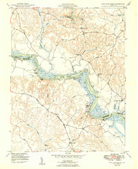
1949 Map of King And Queen
USGS Topo · Published 1949About this map
The Mattaponi Indian Reservation sits along a prominent bend of the Mattaponi River, serving as a central cultural and geographic anchor for this mid-century Virginia landscape. The river dictates the region's character, marked by numerous landings such as Horse Landing, White Oak Landing, and Scotland Landing that reflect a long history of water-based transport and commerce. Inland, the community structure is defined by its rural post offices and country churches, including Stevensville PO, Mattaponi Ch, and Zion Ch. Historical transit paths are preserved through labels for the Pamunkey Trail and the Washington Burgess Route, which intersect the winding creek systems of Market Swamp and Exol Swamp. This survey provides a clear look at the area's agricultural and maritime patterns before modern suburban expansion, documenting local landmarks like the State Fish Hatchery and Bunker Hill Sch.
Find a feature on this map
44 named features on this map. Tap any name to fly to it.
Don’t see what you’re looking for? This feature index may not catch every label — zoom into the map to look around manually.
Map Details
Editions of this 1949 King And Queen Map
2 editions found
Other maps of this area

1918 · Tappahannock
USGS Topo · 1:62,500

1918 · Aylett
USGS Topo · 1:62,500

1919 · New Kent
USGS Topo · 1:62,500

1919 · Tappahannock
USGS Topo · 1:62,500

1920 · King William
USGS Topo · 1:62,500

1933 · Aylett
USGS Topo · 1:62,500

1943 · Richmond
USGS Topo · 1:250,000

1944 · Dunnsville
USGS Topo · 1:31,680
1944 · Howertons
USGS Topo · 1:24,000
1945 · Howertons
USGS Topo · 1:31,680