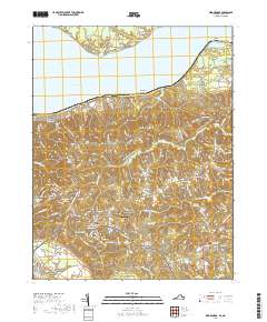
2019 Map of King George
USGS Topo · Published 2019About this map
The Potomac River defines the northern boundary of this coastal Virginia landscape, where the state line meets Maryland at Maryland Point. The interior is a network of creek drainages and small communities centered around the King George County Courthouse. Local genealogy is well-documented through several historic religious sites, including Saint Stephens Baptist Church Cem near Comorn and Peoples Union Baptist Church Cem in the vicinity of Osso.
Find a feature on this map
47 named features on this map. Tap any name to fly to it.
Don’t see what you’re looking for? This feature index may not catch every label — zoom into the map to look around manually.
Map Details
Editions of this 2019 King George Map
This is the sole edition of this map. No revisions or reprints were ever made.
Other maps of this area

1889 · Fredericksburg
USGS Topo · 1:125,000

1892 · Fredericksburg
USGS Topo · 1:125,000

1894 · Fredericksburg
USGS Topo · 1:125,000

1913 · Nanjemoy
USGS Topo · 1:62,500

1926 · Stafford
USGS Topo · 1:62,500

1931 · Stafford
USGS Topo · 1:62,500

1942 · Rollins Fork
USGS Topo · 1:31,680

1942 · Port Royal
USGS Topo · 1:31,680

1942 · Rappahannock Academy
USGS Topo · 1:31,680
1944 · Widewater
USGS Topo · 1:31,680