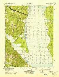
1944 Map of Widewater
USGS Topo · Published 1944About this map
The Potomac River dominates this mid-century survey, dividing the Virginia and Maryland shoreline as the world transitioned from the Second World War. On the Virginia side, the Richmond Fredericksburg and Potomac rail line runs parallel to the coast, serving key points like Aquia Sta and the Midway Island Housing Project. This transportation corridor supported a network of rural hubs including Mountjoy Store, Decatur Store, and Fritters Corner.
Find a feature on this map
46 named features on this map. Tap any name to fly to it.
Don’t see what you’re looking for? This feature index may not catch every label — zoom into the map to look around manually.
Map Details
Editions of this 1944 Widewater Map
This is the sole edition of this map. No revisions or reprints were ever made.
Other maps of this area

1889 · Fredericksburg
USGS Topo · 1:125,000

1890 · Mt. Vernon
USGS Topo · 1:125,000

1891 · Mt. Vernon
USGS Topo · 1:125,000

1892 · Fredericksburg
USGS Topo · 1:125,000

1894 · Fredericksburg
USGS Topo · 1:125,000

1894 · Mt. Vernon
USGS Topo · 1:125,000

1897 · Mt. Vernon
USGS Topo · 1:125,000

1913 · Indian Head
USGS Topo · 1:62,500

1913 · Nanjemoy
USGS Topo · 1:62,500

1923 · Indian Head
USGS Topo · 1:48,000