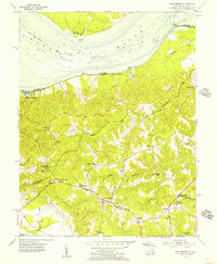
1955 Map of King George
USGS Topo · Published 1956About this map
King George serves as the focal point for this mid-century survey of the Northern Neck, where the landscape is defined by the transition from the wide Potomac River to the wooded interior drainage of Upper Machodoc Creek. The map documents a community deeply rooted in its local institutions, evidenced by a high density of rural churches and family cemeteries such as St Stephens Ch, Potomac Ch, and the Harris Cem. The presence of the Ralph Bunche High School and the Lookout Tower near Edgehill reflect the mid-century civic infrastructure and forestry management of the era.
Find a feature on this map
52 named features on this map. Tap any name to fly to it.
Don’t see what you’re looking for? This feature index may not catch every label — zoom into the map to look around manually.
Map Details
Editions of this 1955 King George Map
This is the sole edition of this map. No revisions or reprints were ever made.
Other maps of this area

1889 · Fredericksburg
USGS Topo · 1:125,000

1892 · Fredericksburg
USGS Topo · 1:125,000

1894 · Fredericksburg
USGS Topo · 1:125,000

1913 · Nanjemoy
USGS Topo · 1:62,500

1926 · Stafford
USGS Topo · 1:62,500

1931 · Stafford
USGS Topo · 1:62,500

1942 · Rollins Fork
USGS Topo · 1:31,680

1942 · Port Royal
USGS Topo · 1:31,680

1942 · Rappahannock Academy
USGS Topo · 1:31,680
1944 · Widewater
USGS Topo · 1:31,680