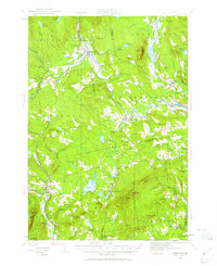
1930 Map of Kingfield
USGS Topo · Published 1961About this map
Carrabassett River and Sandy River anchor this topographic survey, which documents the rural landscape of Franklin and Somerset Counties during the 1930s. The settlement pattern reflects a deeply rooted network of small hamlets and educational outposts, including North Freeman, East New Portland, and Pratt Corner. The map is particularly rich in small schoolhouse locations, such as Starbird Sch, Peabody Sch, and Guild Sch, illustrating the dispersed community structure of these mountain towns before modern school consolidation. Highland landmarks like Gilman Pond Mtn and Boardman Mtn overlook significant water bodies like Porter Lake and Gilman Pond. The presence of the Great Works near New Portland indicates a focus on local production along the streams, while named features such as Hartwell Intervale and Freeman Ridge highlight the intersection of family-named topography and agricultural tradition.
Find a feature on this map
114 named features on this map. Tap any name to fly to it.
Don’t see what you’re looking for? This feature index may not catch every label — zoom into the map to look around manually.
Map Details
Editions of this 1930 Kingfield Map
4 editions found

Other maps of this area

1894 · Norridgewock
USGS Topo · 1:62,500

1898 · Norridgewock
USGS Topo · 1:62,500

1903 · Bingham
USGS Topo · 1:62,500

1904 · Anson
USGS Topo · 1:62,500

1905 · Bingham
USGS Topo · 1:62,500

1924 · Farmington
USGS Topo · 1:62,500

1926 · Dixfield
USGS Topo · 1:62,500

1928 · Dead River
USGS Topo · 1:62,500

1928 · Stratton
USGS Topo · 1:48,000

1929 · Phillips
USGS Topo · 1:48,000