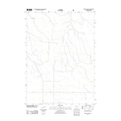
2011 Map of Kings Canyon
USGS Topo · Published 2011About this map
Kings Canyon defines the north-central topography of this Dawes County region, where the high plains of western Nebraska meet deeply incised drainage systems. The landscape is marked by a network of rural routes that follow the natural contours of the land, such as Kings Canyon Rd and Scooped Table Rd. These roads provide access to the remote uplands and the fertile bottoms along Big Bordeaux Creek and Chadron Creek. This early 21st-century survey reflects the enduring cattle ranching and agricultural character of the Nebraska Panhandle, where the distribution of roads like Table Rd and Antelope Rd indicates a sparse, rural settlement pattern typical of the high plains. The map is a precise record of water sources and property access points essential for local land management and genealogical research in this part of the state.
Find a feature on this map
12 named features on this map. Tap any name to fly to it.
Don’t see what you’re looking for? This feature index may not catch every label — zoom into the map to look around manually.
Map Details
Editions of this 2011 Kings Canyon Map
This is the sole edition of this map. No revisions or reprints were ever made.
Other maps of this area

1955 · Alliance
USGS Topo · 1:250,000

1957 · Alliance
USGS Topo · 1:250,000

1958 · Alliance
USGS Topo · 1:250,000

1966 · Chadron 3 SE
USGS Topo · 1:24,000

1966 · Chadron 3 NE
USGS Topo · 1:24,000
1966 · Chadron 3 SW
USGS Topo · 1:24,000

1969 · Bordeaux
USGS Topo · 1:24,000

1970 · Chadron 3 NW
USGS Topo · 1:24,000
1970 · Chadron East
USGS Topo · 1:24,000
1980 · Coffee Mill Butte SE
USGS Topo · 1:24,000