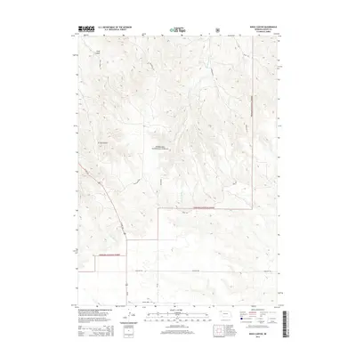
2014 Map of Kings Canyon
USGS Topo · Published 2014About this map
Nebraska National Forest land dominates this section of Dawes County, where the Pine Ridge landscape transitions into the canyon-carved terrain of the high plains. The drainage of Big Bordeaux Cr and Chadron Cr has sculpted significant geological features, most notably Kings Canyon and Strong Canyon in the northwest. This 2014 survey documents a network of rural routes that serve the forest and surrounding ranch lands, including Bordeaux Rd, Spotted Tail Rd, and Prairie Home Rd. The presence of US Hwy 385 provides the primary north-south artery through the western portion of the quadrangle. The map is particularly useful for understanding the modern boundaries and road systems that define the interplay between public timberlands and private agricultural holdings in this corner of the state.
Find a feature on this map
16 named features on this map. Tap any name to fly to it.
Don’t see what you’re looking for? This feature index may not catch every label — zoom into the map to look around manually.
Map Details
Editions of this 2014 Kings Canyon Map
This is the sole edition of this map. No revisions or reprints were ever made.
Other maps of this area

1955 · Alliance
USGS Topo · 1:250,000

1957 · Alliance
USGS Topo · 1:250,000

1958 · Alliance
USGS Topo · 1:250,000

1966 · Chadron 3 SE
USGS Topo · 1:24,000

1966 · Chadron 3 NE
USGS Topo · 1:24,000
1966 · Chadron 3 SW
USGS Topo · 1:24,000

1969 · Bordeaux
USGS Topo · 1:24,000

1970 · Chadron 3 NW
USGS Topo · 1:24,000
1970 · Chadron East
USGS Topo · 1:24,000
1980 · Coffee Mill Butte SE
USGS Topo · 1:24,000