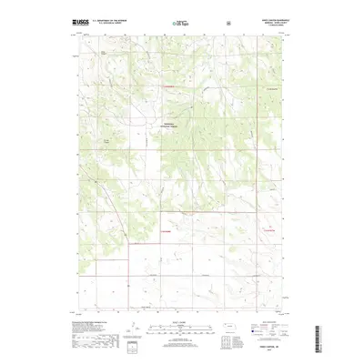
2017 Map of Kings Canyon
USGS Topo · Published 2017About this map
Nebraska National Forest encompasses the northern half of this landscape, where the terrain breaks into the deep incisions of Kings Canyon and Strong Canyon. This 2017 survey by the U.S. Geological Survey documents the distinct transition from the pine-covered escarpments of the forest down to the broad agricultural plateaus to the south. Waterways like Big Bordeaux Cr and Chadron Cr drain the higher elevations, carving the Pine Ridge area of Dawes County. The southern portion of the map reveals a systematic grid of rural transit, including Table Rd and Antelope Rd, which service the isolated ranching and farming operations outside the forest boundary. Named routes such as Spotted Tail Rd and Bordeaux Rd follow the natural contours of the ridges, illustrating how the topography dictates human movement in this part of the Nebraska panhandle.
Find a feature on this map
18 named features on this map. Tap any name to fly to it.
Don’t see what you’re looking for? This feature index may not catch every label — zoom into the map to look around manually.
Map Details
Editions of this 2017 Kings Canyon Map
This is the sole edition of this map. No revisions or reprints were ever made.
Other maps of this area

1955 · Alliance
USGS Topo · 1:250,000

1957 · Alliance
USGS Topo · 1:250,000

1958 · Alliance
USGS Topo · 1:250,000

1966 · Chadron 3 SE
USGS Topo · 1:24,000

1966 · Chadron 3 NE
USGS Topo · 1:24,000
1966 · Chadron 3 SW
USGS Topo · 1:24,000

1969 · Bordeaux
USGS Topo · 1:24,000

1970 · Chadron 3 NW
USGS Topo · 1:24,000
1970 · Chadron East
USGS Topo · 1:24,000
1980 · Coffee Mill Butte SE
USGS Topo · 1:24,000