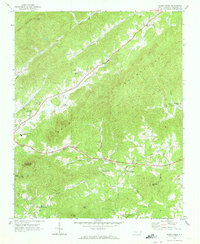
1970 Map of Kings Creek
USGS Topo · Published 1973About this map
The Brushy Mountains dominate this 1970s landscape, where the ridges of Hibriten Mtn and Timbered Ridge shape the development of rural Caldwell County. The settlement of Kings Creek sits at the intersection of mountain valleys, while smaller communities like Draco and Cedar Valley are linked by winding roads that follow the path of the Upper Little River. Cultural landmarks such as Wesley Memorial Ch and St Johns Ch serve the dispersed populations of the foothills, alongside social centers like the Cedar Rock Country Club. This survey reflects an era of local infrastructure growth, evidenced by the Hibriten High Sch and the Lower Creek Airport. The drainage patterns are clearly defined by Millers Creek and McRary Creek, illustrating how the terrain dictated the placement of early homesteads and cemeteries like Blue Ridge Memorial Cem.
Find a feature on this map
44 named features on this map. Tap any name to fly to it.
Don’t see what you’re looking for? This feature index may not catch every label — zoom into the map to look around manually.
Map Details
Editions of this 1970 Kings Creek Map
This is the sole edition of this map. No revisions or reprints were ever made.
Other maps of this area

1889 · Wilkesboro
USGS Topo · 1:125,000

1891 · Wilkesboro
USGS Topo · 1:125,000

1893 · Cranberry
USGS Topo · 1:125,000

1895 · Hickory
USGS Topo · 1:125,000

1895 · Cranberry
USGS Topo · 1:125,000

1899 · Cranberry
USGS Topo · 1:125,000

1902 · Cranberry
USGS Topo · 1:125,000

1905 · Morganton
USGS Topo · 1:125,000

1936 · Blowing Rock
USGS Topo · 1:48,000

1942 · Blowing Rock
USGS Topo · 1:62,500