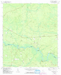
1970 Map of Kings Ferry
USGS Topo · Published 1992About this map
The ST Marys River carves a winding path along the state boundary between Georgia and Florida, anchoring a landscape defined by riverside landings and rural settlements. This 1970 survey, with updates from the early 1990s, documents a community structured around the river economy and local faith, featuring numerous small congregations such as Spring Hill Ch, Oak Hill Ch, and Mt Olive Ch. The geography is notably heavy with family-named landmarks and infrastructure, from Mallets Landing to Brickyard Landing. Inland from the river bluffs, the terrain gives way to the expansive Cabbage Swamp, while scattered settlements like Kings Ferry and Greenville remain connected by rural routes such as Lessie Road. This map is particularly valuable for genealogical research, pinpointing several local burial grounds including Mallets Cem and Haddock Cem near the riverbanks.
Find a feature on this map
32 named features on this map. Tap any name to fly to it.
Don’t see what you’re looking for? This feature index may not catch every label — zoom into the map to look around manually.
Map Details
Editions of this 1970 Kings Ferry Map
3 editions found
Other maps of this area

1917 · Boulogne
USGS Topo · 1:62,500

1917 · Hilliard
USGS Topo · 1:62,500

1918 · St Marys
USGS Topo · 1:62,500

1918 · Kingsland
USGS Topo · 1:62,500

1919 · St Marys
USGS Topo · 1:62,500

1919 · Hilliard
USGS Topo · 1:62,500

1919 · Boulogne
USGS Topo · 1:62,500

1948 · Jacksonville
USGS Topo · 1:250,000

1957 · Jacksonville
USGS Topo · 1:250,000

1958 · Gross
USGS Topo · 1:24,000