1976 Map of Kings Mountain
USGS Topo · Published 1978About this map
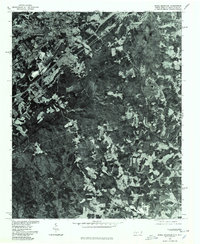
Kings Mountain sits in the northwestern corner of this 1970s orthophotoquad, showing a transition between industrial excavation and the dense forest of the Piedmont. The aerial perspective, captured in early 1976, reveals large open-pit mining operations and cleared tracts that define the local economy south of the urban center. Unlike a traditional topographic map, this imagery records the actual land usage of the era, from the geometric patterns of residential development to the sprawling timberlands and agricultural clearings near Henry Knob in the south.
Find a feature on this map
4 named features on this map. Tap any name to fly to it.
Don’t see what you’re looking for? This feature index may not catch every label — zoom into the map to look around manually.
Map Details
Editions of this 1976 Kings Mountain Map
This is the sole edition of this map. No revisions or reprints were ever made.
Other maps of this area

1906 · Kings Mountain
USGS Topo · 1:62,500

1908 · Kings Mountain
USGS Topo · 1:62,500

1909 · Lincolnton
USGS Topo · 1:62,500

1911 · Lincolnton
USGS Topo · 1:62,500

1914 · Gastonia
USGS Topo · 1:48,000

1916 · Gastonia
USGS Topo · 1:62,500

1947 · Clover
USGS Topo · 1:62,500

1949 · Clover
USGS Topo · 1:62,500

1953 · Charlotte
USGS Topo · 1:250,000

1954 · Charlotte
USGS Topo · 1:250,000