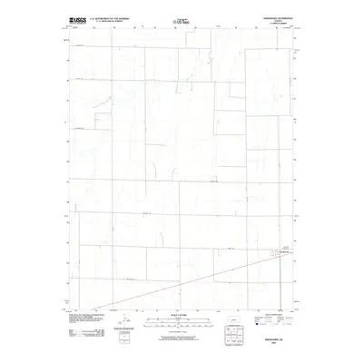
2009 Map of Kingsdown
USGS Topo · Published 2009About this map
Kingsdown serves as the primary focal point of this rural Kansas landscape, situated in the southeastern corner of the quadrangle. The settlement's orientation is defined by the intersection of the regional highway and a strictly gridded network of section-line roads, including Windy Rd and 125 Rd. A short distance north of the town site lies the Sodville Cemetery, providing a significant touchstone for local genealogy and family history in this portion of Ford County.
Find a feature on this map
16 named features on this map. Tap any name to fly to it.
Don’t see what you’re looking for? This feature index may not catch every label — zoom into the map to look around manually.
Map Details
Editions of this 2009 Kingsdown Map
This is the sole edition of this map. No revisions or reprints were ever made.
Other maps of this area

1892 · Spearville
USGS Topo · 1:125,000

1894 · Spearville
USGS Topo · 1:125,000

1896 · Ashland
USGS Topo · 1:125,000

1955 · Pratt
USGS Topo · 1:250,000

1959 · Pratt
USGS Topo · 1:250,000

1967 · Bloom
USGS Topo · 1:24,000
1969 · Fort Dodge SW
USGS Topo · 1:24,000

1969 · Fort Dodge
USGS Topo · 1:24,000

1969 · Bucklin
USGS Topo · 1:24,000

1969 · Kingsdown
USGS Topo · 1:24,000