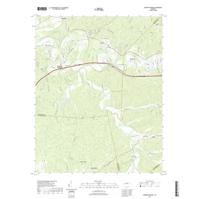
2019 Map of Kingston Springs
USGS Topo · Published 2019About this map
The Harpeth River and South Harpeth River carve through the landscape of Cheatham, Davidson, and Williamson counties, dictating the development of riverside communities like Kingston Springs and Pegram. In this 2019 data, the influence of the CSX Transportation line and the proximity of Interstate 40 at Buffalo Gap are visible markers of the region's role as a transit corridor west of Nashville. Significant memorial sites are distributed throughout the terrain, including the Middle Tennessee State Veterans Cem and Harpeth Hills Memory Gardens. Local history is preserved in several smaller burial grounds such as Mount Pleasant Cem and Thornton Cem. The southern portion of the quadrangle transitions into the settlements of Linton and Fairview, where the topography is defined by drainage systems like Brush Creek and Poplar Cr.
Find a feature on this map
124 named features on this map. Tap any name to fly to it.
Don’t see what you’re looking for? This feature index may not catch every label — zoom into the map to look around manually.
Map Details
Editions of this 2019 Kingston Springs Map
This is the sole edition of this map. No revisions or reprints were ever made.
Other maps of this area

1901 · Colombia
USGS Topo · 1:125,000

1903 · Nashville
USGS Topo · 1:125,000

1909 · Franklin
USGS Topo · 1:62,500

1930 · White Bluff
USGS Topo · 1:62,500

1932 · Nashville
USGS Topo · 1:62,500

1933 · White Bluff
USGS Topo · 1:62,500

1936 · Craigfield
USGS Topo · 1:24,000

1946 · Leipers Fork
USGS Topo · 1:24,000

1949 · Leipers Fork
USGS Topo · 1:24,000

1951 · Fairview
USGS Topo · 1:24,000