
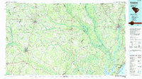
1986 Map of Kingstree
USGS Topo · Published 1986About this map
Kingstree and the winding course of the Black River define this mid-1980s look at the South Carolina Lowcountry. The map captures a transitional era for the region's transport, showing the Seaboard System Railroad serving inland hubs like Lake City and Salters Depot while the coastal tourism economy centers around Garden City Beach, Pawleys Island, and the Intracoastal Waterway. The river systems here are the primary geographic organizers, from the Lynches River in the west to the confluence of the Pee Dee and Little Pee Dee River in the east.
Find a feature on this map
82 named features on this map. Tap any name to fly to it.
Don’t see what you’re looking for? This feature index may not catch every label — zoom into the map to look around manually.
Map Details
Editions of this 1986 Kingstree Map
2 editions found
Other maps of this area

1920 · Chicora
USGS Topo · 1:48,000

1920 · Mayesville
USGS Topo · 1:48,000

1920 · Manning
USGS Topo · 1:48,000

1921 · Chicora
USGS Topo · 1:62,500

1921 · Manning
USGS Topo · 1:62,500

1921 · Mayesville
USGS Topo · 1:62,500

1937 · Myrtle Beach
USGS Topo · 1:48,000

1937 · Nixonville
USGS Topo · 1:48,000

1940 · Florence West
USGS Topo · 1:62,500

1940 · Myrtle Beach
USGS Topo · 1:62,500