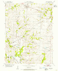
1954 Map of Kingsville
USGS Topo · Published 1955About this map
Kingsville and its surrounding townships in Johnson County serve as a crossroads for several major mid-century rail lines. The landscape is defined by the convergence of the Missouri Pacific, Missouri Kansas Texas, and Chicago Rock Island and Pacific railroads, which linked small rural communities like Medford and Latour to the broader regional economy. This network of tracks navigates a terrain of creeks and branches, including Big Creek and Coon Creek, where agricultural life is evidenced by numerous local landmarks.
Find a feature on this map
37 named features on this map. Tap any name to fly to it.
Don’t see what you’re looking for? This feature index may not catch every label — zoom into the map to look around manually.
Map Details
Editions of this 1954 Kingsville Map
2 editions found
Other maps of this area

1885 · Warrensburg
USGS Topo · 1:125,000

1887 · Harrisonville
USGS Topo · 1:125,000

1887 · Warrensburg
USGS Topo · 1:125,000

1892 · Harrisonville
USGS Topo · 1:125,000

1894 · Harrisonville
USGS Topo · 1:125,000

1894 · Warrensburg
USGS Topo · 1:125,000

1947 · Jefferson City
USGS Topo · 1:250,000

1947 · Lawrence
USGS Topo · 1:250,000

1950 · Lawrence
USGS Topo · 1:250,000

1954 · Jefferson City
USGS Topo · 1:250,000