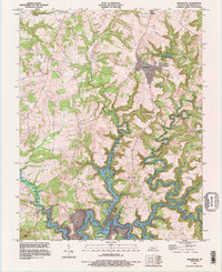
1993 Map of Kingswood
USGS Topo · Published 1996About this map
Rough River Lake dominates the southern landscape of this 1993 Breckinridge County survey, showcasing the complex, winding shoreline created by the impoundment of the Rough River. The map documents the rural character of the region during the late twentieth century, centered around small communities like Kingswood, Westview, and Harned. The rugged topography is defined by the deep valleys of White Oak Creek and Tules Creek, where numerous unnamed cemeteries are scattered among the ridges, offering valuable data for genealogists tracing family land holdings. On the lake's edge, recreational developments such as Picnic Area Site C and the settlement of Axtel appear alongside the industrial infrastructure of the USDA Flood Control Dam. This edition provides a clear record of the intersection between natural watercourses like the North Fork Rough River and the engineered lake environment.
Find a feature on this map
23 named features on this map. Tap any name to fly to it.
Don’t see what you’re looking for? This feature index may not catch every label — zoom into the map to look around manually.
Map Details
Editions of this 1993 Kingswood Map
This is the sole edition of this map. No revisions or reprints were ever made.
Other maps of this area

1928 · Hardinsburg
USGS Topo · 1:48,000

1931 · Hardinsburg
USGS Topo · 1:62,500

1932 · Fordsville
USGS Topo · 1:62,500

1934 · Cannelton
USGS Topo · 1:62,500

1947 · Hardinsburg
USGS Topo · 1:24,000

1947 · Garfield
USGS Topo · 1:24,000

1947 · Hardinsburg
USGS Topo · 1:62,500

1953 · Custer
USGS Topo · 1:24,000

1953 · Mc Daniels
USGS Topo · 1:24,000

1953 · Hardinsburg
USGS Topo · 1:24,000