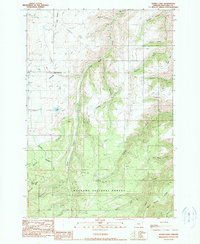
1990 Map of Kinney Lake
USGS Topo · Published 1990About this map
Wallowa National Forest land dominates this northeastern Oregon terrain, where the high ridges and steep canyons of the Wallowa Mountains descend toward the valley floor. The Wallowa Valley Improvement Canal provides a stark marker of human engineering, cutting across the landscape to redirect water for agricultural use in the lower elevations. The map reveals a complex hydrological network defined by the diverging paths of Little Sheep Creek and Big Sheep Creek, which have carved significant features such as Rail Canyon and Mitchell Canyon. Resource extraction is evident in several Quarry sites located near Sheep Creek Hill, while the remote high-country character is maintained around Pappose Lake and the crest of Pappose Ridge. Small-scale features like Cold Springs and the many named gulches suggest a landscape shaped by seasonal water and high-altitude ranching or forestry.
Find a feature on this map
32 named features on this map. Tap any name to fly to it.
Don’t see what you’re looking for? This feature index may not catch every label — zoom into the map to look around manually.
Map Details
Editions of this 1990 Kinney Lake Map
This is the sole edition of this map. No revisions or reprints were ever made.
Other maps of this area

1954 · Cornucopia
USGS Topo · 1:62,500

1954 · Harl Butte
USGS Topo · 1:62,500

1955 · Grangeville
USGS Topo · 1:250,000

1957 · Joseph
USGS Topo · 1:62,500

1957 · Homestead
USGS Topo · 1:62,500

1959 · Grangeville
USGS Topo · 1:250,000

1986 · Enterprise
USGS Topo · 1:100,000

1987 · Riggins
USGS Topo · 1:100,000
1990 · Gumboot Butte
USGS Topo · 1:24,000
1990 · Joseph
USGS Topo · 1:24,000