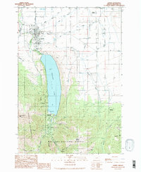
1990 Map of Joseph
USGS Topo · Published 1990About this map
The town of Joseph sits at the foot of dramatic alpine peaks, serving as the gateway to the massive Wallowa Lake and the high country beyond. In the early 1990s, the area's transition from a mountain agricultural community to a recreation hub is visible, with Wallowa Lake State Park occupying the lake's southern shore. The irrigation network of Prairie Creek and the Wallowa River supports the valley floor, while the rugged southern terrain is preserved within the Eagle Cap Wilderness and Wallowa National Forest. Local history is deeply etched into the landscape here, from the High Sch and Liberty Grange to the mining legacy found at the Royal Purple Mine and Transvaal Mines on the slopes of Mount Howard. Genealogists will find three distinct burial sites: Joseph Cem, Prairie Creek Cem, and the Chief Joseph Cem.
Find a feature on this map
23 named features on this map. Tap any name to fly to it.
Don’t see what you’re looking for? This feature index may not catch every label — zoom into the map to look around manually.
Map Details
Editions of this 1990 Joseph Map
2 editions found
Other maps of this area

1954 · Cornucopia
USGS Topo · 1:62,500

1954 · Eagle Cap
USGS Topo · 1:62,500

1955 · Grangeville
USGS Topo · 1:250,000

1957 · Enterprise
USGS Topo · 1:62,500

1957 · Joseph
USGS Topo · 1:62,500

1959 · Grangeville
USGS Topo · 1:250,000

1986 · Enterprise
USGS Topo · 1:100,000

1990 · Chief Joseph Mtn
USGS Topo · 1:24,000
1990 · Eagle Cap
USGS Topo · 1:24,000
1990 · Three Lakes Country
USGS Topo · 1:24,000