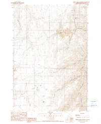
1990 Map of Three Lakes Country
USGS Topo · Published 1990About this map
Lightning Creek Ranch stands as a primary marker of human activity in this corner of Wallowa County, situated where the North Fork and South Fork converge. The landscape is defined by its complex drainage systems, featuring the steep descents of Box Canyon and the winding course of Little Sheep Creek.
Find a feature on this map
20 named features on this map. Tap any name to fly to it.
Don’t see what you’re looking for? This feature index may not catch every label — zoom into the map to look around manually.
Map Details
Editions of this 1990 Three Lakes Country Map
This is the sole edition of this map. No revisions or reprints were ever made.
Other maps of this area

1954 · Imnaha
USGS Topo · 1:62,500

1954 · Harl Butte
USGS Topo · 1:62,500

1955 · Grangeville
USGS Topo · 1:250,000

1957 · Joseph
USGS Topo · 1:62,500

1957 · Elk Mountain
USGS Topo · 1:62,500

1959 · Grangeville
USGS Topo · 1:250,000

1980 · Grangeville
USGS Topo · 1:100,000

1982 · Wallowa
USGS Topo · 1:100,000

1986 · Enterprise
USGS Topo · 1:100,000

1987 · Riggins
USGS Topo · 1:100,000