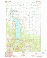
1990 Map of Joseph
USGS Topo · Published 1990About this map
Joseph serves as the focal point of this northeastern Oregon landscape, positioned at the northern tip of the deep Wallowa Lake. The map reveals a transition from the agricultural irrigation networks of the north, including the Moonshine Ditch and numerous unnamed ditches, to the steep alpine terrain of the south. High peaks like Chief Joseph Mtn and Mount Howard tower over the Eagle Cap Wilderness and Wallowa National Forest. Local community life is documented through markers like the Liberty Grange and the High Sch.
Find a feature on this map
29 named features on this map. Tap any name to fly to it.
Don’t see what you’re looking for? This feature index may not catch every label — zoom into the map to look around manually.
Map Details
Editions of this 1990 Joseph Map
2 editions found
Other maps of this area

1954 · Cornucopia
USGS Topo · 1:62,500

1954 · Eagle Cap
USGS Topo · 1:62,500

1955 · Grangeville
USGS Topo · 1:250,000

1957 · Enterprise
USGS Topo · 1:62,500

1957 · Joseph
USGS Topo · 1:62,500

1959 · Grangeville
USGS Topo · 1:250,000

1986 · Enterprise
USGS Topo · 1:100,000

1990 · Chief Joseph Mtn
USGS Topo · 1:24,000
1990 · Eagle Cap
USGS Topo · 1:24,000
1990 · Joseph
USGS Topo · 1:24,000