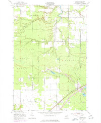
1951 Map of Kinross
USGS Topo · Published 1977About this map
Kinross serves as the focal point for this survey of Michigan's Upper Peninsula, where the Minneapolis St Paul and Sault Ste Marie railroad cuts diagonally across the landscape. The geography is defined by a transition between the Superior National Forest and the Munuscong State Forest, showing a mix of managed timberland and agricultural clearings. Local life is anchored by institutions like the Holland Sch and Christian Sch, alongside the prominent Kinross Tower. The 1975 revisions highlight developments such as a major Pipeline and a Transformer Sta, while the hydrology is dominated by the Munuscong River and the many branches of Hutton Creek. Genealogists will find three distinct burial sites, including the Rudyard Cem, Kinross Cem, and Lake View Cem, providing specific locations for historical research.
Find a feature on this map
26 named features on this map. Tap any name to fly to it.
Don’t see what you’re looking for? This feature index may not catch every label — zoom into the map to look around manually.
Map Details
Editions of this 1951 Kinross Map
2 editions found
Other maps of this area

1913 · Sault Sainte Marie
USGS Topo · 1:62,500

1941 · Sault Sainte Marie
USGS Topo · 1:63,360

1941 · Brimley
USGS Topo · 1:63,360

1951 · Shallows
USGS Topo · 1:24,000

1951 · Dollar Settlement
USGS Topo · 1:24,000

1951 · Raco
USGS Topo · 1:24,000

1951 · Kinross
USGS Topo · 1:24,000

1951 · Dafter
USGS Topo · 1:24,000

1951 · Brimley
USGS Topo · 1:62,500

1951 · Sault Ste. Marie
USGS Topo · 1:62,500