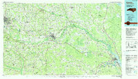
1985 Map of Kinston
USGS Topo · Published 1990About this map
The Neuse River winds through the heart of Eastern North Carolina, serving as a geographic anchor for the region in the mid-1980s. This survey highlights a landscape where agriculture and industry meet massive coastal ecosystems like the Great Dover Swamp and the Croatan National Forest. The city of Kinston stands as a central hub, flanked by institutional landmarks such as Lenoir Community College and the aviation activity at Kinston Regional Jetport at Stallings.
Find a feature on this map
295 named features on this map. Tap any name to fly to it.
Don’t see what you’re looking for? This feature index may not catch every label — zoom into the map to look around manually.
Map Details
Editions of this 1985 Kinston Map
2 editions found
Other maps of this area

1901 · New Bern
USGS Topo · 1:62,500

1902 · Kenly
USGS Topo · 1:62,500

1902 · Ayden
USGS Topo · 1:62,500

1902 · Vanceboro
USGS Topo · 1:62,500

1903 · Kenly
USGS Topo · 1:62,500

1903 · New Bern
USGS Topo · 1:62,500

1903 · Winterville
USGS Topo · 1:62,500

1903 · Trent River
USGS Topo · 1:62,500

1903 · Chocowinity
USGS Topo · 1:62,500

1904 · Ayden
USGS Topo · 1:62,500