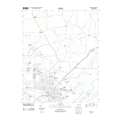
2010 Map of Kinston
USGS Topo · Published 2010About this map
The Neuse River winds through this 2010 survey of Lenoir County, where the city of Kinston serves as a dense hub of residential and commercial development. The map details a transition from the structured urban grid of neighborhoods like Westwood and Eastover to the surrounding rural plains marked by historic crossroads. Local landmarks such as the Kinston Post Office, the Lenoir County Chamber of Commerce, and the historic Harmony Hall anchor the city center, while sprawling burial grounds like Maplewood Cemetery and Oak Hill Cemetery provide significant points of interest for genealogists.
Find a feature on this map
99 named features on this map. Tap any name to fly to it.
Don’t see what you’re looking for? This feature index may not catch every label — zoom into the map to look around manually.
Map Details
Editions of this 2010 Kinston Map
This is the sole edition of this map. No revisions or reprints were ever made.
Other maps of this area

1902 · Ayden
USGS Topo · 1:62,500

1903 · Trent River
USGS Topo · 1:62,500

1904 · Ayden
USGS Topo · 1:62,500

1904 · Trent River
USGS Topo · 1:62,500

1914 · Kinston
USGS Topo · 1:48,000

1916 · Kinston
USGS Topo · 1:62,500

1953 · Rocky Mount
USGS Topo · 1:250,000

1954 · Rocky Mount
USGS Topo · 1:250,000

1958 · Deep Run
USGS Topo · 1:62,500
1980 · Deep Run
USGS Topo · 1:24,000