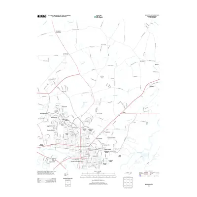
2013 Map of Kinston
USGS Topo · Published 2013About this map
Kinston Regional Jetport at Stallings Field occupies the northwest portion of this modern survey, reflecting the city's role as a regional transportation hub. The town's expansion is evident through numerous residential developments such as Sherwood Forest, Lenoir Pines, and Howard Heights. The historic core near the Neuse River includes Harmony Hall, marking a site of deep local significance.
Find a feature on this map
247 named features on this map. Tap any name to fly to it.
Don’t see what you’re looking for? This feature index may not catch every label — zoom into the map to look around manually.
Map Details
Editions of this 2013 Kinston Map
This is the sole edition of this map. No revisions or reprints were ever made.
Other maps of this area

1902 · Ayden
USGS Topo · 1:62,500

1903 · Trent River
USGS Topo · 1:62,500

1904 · Ayden
USGS Topo · 1:62,500

1904 · Trent River
USGS Topo · 1:62,500

1914 · Kinston
USGS Topo · 1:48,000

1916 · Kinston
USGS Topo · 1:62,500

1953 · Rocky Mount
USGS Topo · 1:250,000

1954 · Rocky Mount
USGS Topo · 1:250,000

1958 · Deep Run
USGS Topo · 1:62,500
1980 · Deep Run
USGS Topo · 1:24,000