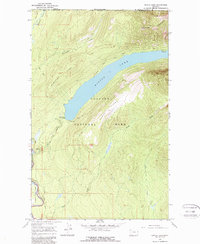
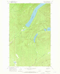
1966 Map of Kintla Lake
USGS Topo · Published 1987About this map
Glacier National Park defines the rugged topography of this borderland, where the Canada United States international boundary cuts across the high peaks of the Boundary Mountains. The elongated basin of Kintla Lake dominates the central landscape, serving as a focal point for wilderness travel along the Boulder Pass Trail and various Pack Trails. The presence of a Patrol Cabin and the Kintla Lake Campground at the foot of the water indicates the area's role as a remote outpost for forest management and early backcountry recreation.
Find a feature on this map
23 named features on this map. Tap any name to fly to it.
Don’t see what you’re looking for? This feature index may not catch every label — zoom into the map to look around manually.
Map Details
Editions of this 1966 Kintla Lake Map
2 editions found
Other maps of this area

1906 · Kintla Lakes
USGS Topo · 1:125,000

1938 · Kintla Lakes
USGS Topo · 1:125,000

1957 · Kalispell
USGS Topo · 1:250,000

1960 · Kalispell
USGS Topo · 1:250,000

1961 · Kalispell
USGS Topo · 1:250,000

1966 · Kintla Lake
USGS Topo · 1:24,000
1966 · Whale Buttes
USGS Topo · 1:24,000
1966 · Polebridge
USGS Topo · 1:24,000
1966 · Trailcreek
USGS Topo · 1:24,000
1968 · Quartz Ridge
USGS Topo · 1:24,000