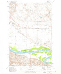
1972 Map of Kintyre
USGS Topo · Published 1976About this map
The Missouri River snakes across this landscape, serving as a critical artery where the Milk River joins from the northwest. In the early 1970s, this region was defined by its water management and transportation infrastructure, anchored by the Burlington Northern railroad corridor. The Fort Peck Indian Reservation Boundary follows the river's path, separating the northern plains from the coulees and creek beds to the south.
Find a feature on this map
18 named features on this map. Tap any name to fly to it.
Don’t see what you’re looking for? This feature index may not catch every label — zoom into the map to look around manually.
Map Details
Editions of this 1972 Kintyre Map
This is the sole edition of this map. No revisions or reprints were ever made.
Other maps of this area

1914 · Nashua
USGS Topo · 1:62,500

1915 · Frazer
USGS Topo · 1:62,500

1916 · Nashua
USGS Topo · 1:62,500

1954 · Jordan
USGS Topo · 1:250,000

1954 · Glasgow
USGS Topo · 1:250,000

1956 · Jordan
USGS Topo · 1:250,000

1957 · Glasgow
USGS Topo · 1:250,000

1958 · Glasgow
USGS Topo · 1:250,000

1958 · Jordan
USGS Topo · 1:250,000

1964 · Jordan
USGS Topo · 1:250,000