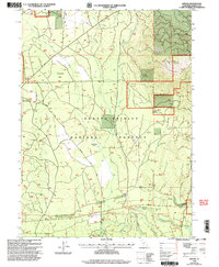
1998 Map of Kinyon
USGS Topo · Published 2003About this map
Shasta-Trinity National Forest dominates this northern California landscape, where the high elevations of Black Fox Mountain overlook a complex network of seasonal drainages and volcanic terrain. Historical movement through these mountains is etched into the map by Military Pass Road, a path through the timbered flats and volcanic rises. The small settlements of Kinyon, Pilgrim, and Ash Creek are scattered among the timberlands, supported by the Volcanic Scenic Byway and recreational infrastructure like the Pilgrim Creek Snowmobile Park.
Find a feature on this map
32 named features on this map. Tap any name to fly to it.
Don’t see what you’re looking for? This feature index may not catch every label — zoom into the map to look around manually.
Map Details
Editions of this 1998 Kinyon Map
2 editions found
Other maps of this area

1886 · Modoc Lava Bed
USGS Topo · 1:250,000

1886 · Shasta
USGS Topo · 1:250,000

1892 · Modoc Lava-Bed
USGS Topo · 1:250,000

1894 · Shasta
USGS Topo · 1:250,000

1932 · Bartle
USGS Topo · 1:96,000

1935 · Dunsmuir
USGS Topo · 1:125,000

1939 · Bartle
USGS Topo · 1:125,000

1948 · Weed
USGS Topo · 1:250,000

1950 · Weed
USGS Topo · 1:250,000

1954 · Shoeinhorse Mountain
USGS Topo · 1:62,500