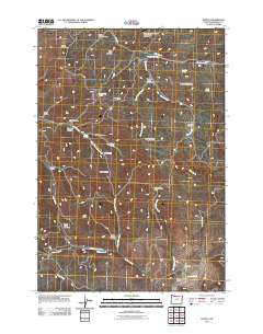
2011 Map of Kinzua
USGS Topo · Published 2011About this map
Kinzua Mountain dominates the northern reaches of this high-desert landscape in Wheeler County, where seasonal drainages and named springs provide vital water points in a dry terrain. The map reveals a land structured by its relief, from the broad expanse of Searcy Flat to the sharp descent of Hells Half Acre. Travel through this region is defined by corridors like Kinzua Rd and Lonerock Rd, which connect the isolated Kinzua General Aviation Recreational Airport to the southern valleys. To the south, the watershed of Service Creek and its various forks creates a network of canyons including Emery Canyon, while the Shelton State Wayside offers a rare public landmark along the creek's edge. The presence of Prairie Ranch in the southeast suggests the ongoing importance of livestock and ranching in this sparsely populated interior of Oregon.
Find a feature on this map
42 named features on this map. Tap any name to fly to it.
Don’t see what you’re looking for? This feature index may not catch every label — zoom into the map to look around manually.
Map Details
Editions of this 2011 Kinzua Map
This is the sole edition of this map. No revisions or reprints were ever made.
Other maps of this area

1916 · Condon
USGS Topo · 1:125,000

1926 · Mitchell
USGS Topo · 1:125,000

1953 · Spray
USGS Topo · 1:62,500

1953 · Pendleton
USGS Topo · 1:250,000

1953 · The Dalles
USGS Topo · 1:250,000

1955 · Bend
USGS Topo · 1:250,000

1955 · Canyon City
USGS Topo · 1:250,000

1956 · The Dalles
USGS Topo · 1:250,000

1956 · Pendleton
USGS Topo · 1:250,000

1957 · Bend
USGS Topo · 1:250,000