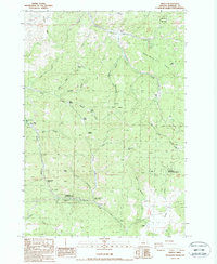
1987 Map of Kinzua
USGS Topo · Published 1988About this map
Kinzua (Site) anchors this portion of Wheeler County, appearing here as a former settlement site alongside its Kinzua Landing Strip. The landscape is defined by the transition between timbered high ground and deep canyon drainages, with the Umatilla National Forest covering the northern and eastern reaches. Significant local relief is marked by landmarks such as Butte Creek Summit and the curiously named Hells Half Acre, while numerous springs like Walton Spring and Kinzua Springs suggest the importance of water sources in this arid environment.
Find a feature on this map
46 named features on this map. Tap any name to fly to it.
Don’t see what you’re looking for? This feature index may not catch every label — zoom into the map to look around manually.
Map Details
Editions of this 1987 Kinzua Map
This is the sole edition of this map. No revisions or reprints were ever made.
Other maps of this area

1916 · Condon
USGS Topo · 1:125,000

1926 · Mitchell
USGS Topo · 1:125,000

1953 · Spray
USGS Topo · 1:62,500

1953 · Pendleton
USGS Topo · 1:250,000

1953 · The Dalles
USGS Topo · 1:250,000

1955 · Bend
USGS Topo · 1:250,000

1955 · Canyon City
USGS Topo · 1:250,000

1956 · The Dalles
USGS Topo · 1:250,000

1956 · Pendleton
USGS Topo · 1:250,000

1957 · Bend
USGS Topo · 1:250,000