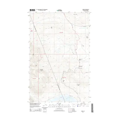
2014 Map of Kiowa
USGS Topo · Published 2014About this map
Glacier National Park defines the western edge of this landscape, where the high peaks of Mad Wolf Mtn, Basin Mtn, and Spot Mtn rise above the foothills. The settlement of Kiowa sits at the junction of MT-49 and Us-89, serving as a gateway to the mountains. The terrain is marked by significant hydrological divides, including Milk River Ridge and Cut Bank Ridge, which separate the headwaters of several major prairie-bound streams. Along the eastern slopes, the Schildt Cem and early access routes like Starr School Rd and Racine Basin Rd indicate the area's transition from the protected alpine wilderness to the grazing lands and local communities of the Blackfeet Reservation. Engineering landmarks such as the South Fork of Cut Bank Creek Bridge illustrate the infrastructure required to navigate this drainage-rich environment.
Find a feature on this map
38 named features on this map. Tap any name to fly to it.
Don’t see what you’re looking for? This feature index may not catch every label — zoom into the map to look around manually.
Map Details
Editions of this 2014 Kiowa Map
This is the sole edition of this map. No revisions or reprints were ever made.
Other maps of this area

1901 · Browning
USGS Topo · 1:125,000

1903 · Browning
USGS Topo · 1:125,000

1913 · Marias Pass
USGS Topo · 1:125,000

1960 · Cut Bank
USGS Topo · 1:250,000

1963 · Cut Bank
USGS Topo · 1:250,000

1964 · Cut Bank
USGS Topo · 1:250,000

1968 · Saint Mary
USGS Topo · 1:24,000

1968 · Josephine
USGS Topo · 1:24,000
1968 · Cut Bank Pass
USGS Topo · 1:24,000
1968 · Kiowa
USGS Topo · 1:24,000