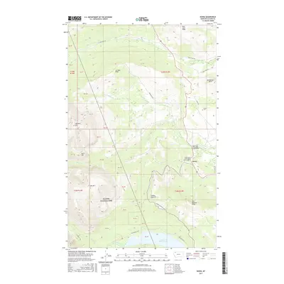
2017 Map of Kiowa
USGS Topo · Published 2017About this map
Kiowa sits at the junction of modern travel routes and ancient mountain passes along the eastern edge of Glacier National Park. This survey captures the transition from the high peaks of the Lewis Range to the open ranching country of the Blackfeet Indian Reservation. Local genealogy is anchored by the Schildt Cem and family-named routes such as Schildt Rd and Starr School Rd. The landscape is defined by the continental divide's runoff, including the S Fork Cut Bank Cr and Two Medicine Cr, which flows into Lower Two Medicine Lake. Significant topographic landmarks like Mad Wolf Mtn, Red Blanket Butte, and Looking Glass Hill provide a clear view of the complex terrain that has long dictated movement through Pitamakan Pass.
Find a feature on this map
42 named features on this map. Tap any name to fly to it.
Don’t see what you’re looking for? This feature index may not catch every label — zoom into the map to look around manually.
Map Details
Editions of this 2017 Kiowa Map
This is the sole edition of this map. No revisions or reprints were ever made.
Other maps of this area

1901 · Browning
USGS Topo · 1:125,000

1903 · Browning
USGS Topo · 1:125,000

1913 · Marias Pass
USGS Topo · 1:125,000

1960 · Cut Bank
USGS Topo · 1:250,000

1963 · Cut Bank
USGS Topo · 1:250,000

1964 · Cut Bank
USGS Topo · 1:250,000

1968 · Saint Mary
USGS Topo · 1:24,000

1968 · Josephine
USGS Topo · 1:24,000
1968 · Cut Bank Pass
USGS Topo · 1:24,000
1968 · Kiowa
USGS Topo · 1:24,000