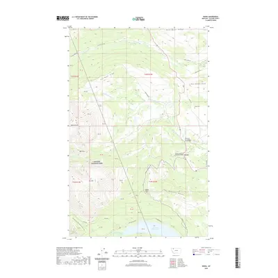
2020 Map of Kiowa
USGS Topo · Published 2020About this map
Glacier National Park defines the western portion of this 2020 terrain study, where the peaks of Mad Wolf Mtn and Basin Mtn overlook the transition from alpine heights to the high plains. The settlement of Kiowa serves as a central point along the eastern front, situated near the South Fork of the Milk River Bridge. This landscape is marked by prominent topographic divides, including Milk River Ridge and Two Medicine Ridge, which direct the flow of waters through the N Fork Cut Bank Cr and Two Medicine Cr. Hikers can trace the path of the Continental Divide National Scenic Trail as it winds through the southwestern corner. Local history and family ties are evident in features like Schildt Cem and named roads such as Starr School Rd and Racine Basin Rd, reflecting the ranching and rural infrastructure of Glacier County.
Find a feature on this map
41 named features on this map. Tap any name to fly to it.
Don’t see what you’re looking for? This feature index may not catch every label — zoom into the map to look around manually.
Map Details
Editions of this 2020 Kiowa Map
This is the sole edition of this map. No revisions or reprints were ever made.
Other maps of this area

1901 · Browning
USGS Topo · 1:125,000

1903 · Browning
USGS Topo · 1:125,000

1913 · Marias Pass
USGS Topo · 1:125,000

1960 · Cut Bank
USGS Topo · 1:250,000

1963 · Cut Bank
USGS Topo · 1:250,000

1964 · Cut Bank
USGS Topo · 1:250,000

1968 · Saint Mary
USGS Topo · 1:24,000

1968 · Josephine
USGS Topo · 1:24,000
1968 · Cut Bank Pass
USGS Topo · 1:24,000
1968 · Kiowa
USGS Topo · 1:24,000