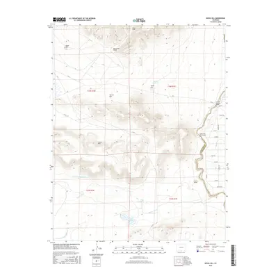
2016 Map of Kiowa Hill
USGS Topo · Published 2016About this map
Kiowa Hill and the surrounding volcanic terrain of the San Luis Hills dominate this portion of the southern San Luis Valley. The landscape is defined by the sharp transition between these arid uplands and the fertile riparian corridor of the Rio Grande. Irrigation infrastructure, critical to local agriculture, is represented by the Taos Valley Ditch Number 2 and Taos Valley Ditch Number 1, which draw from the river's flow. Significant geographical landmarks such as Island Rock and the deep John James Canyon punctuate the high ground, while the eastern edge follows the dramatic Cañon del Rio Grande where the river cuts through the valley floor. Transportation and water management are centralized at the Costilla Crossing Bridge and nearby catchment areas like Apache Reservoir and Park Lake.
Find a feature on this map
34 named features on this map. Tap any name to fly to it.
Don’t see what you’re looking for? This feature index may not catch every label — zoom into the map to look around manually.
Map Details
Editions of this 2016 Kiowa Hill Map
This is the sole edition of this map. No revisions or reprints were ever made.
Other maps of this area

1954 · Raton
USGS Topo · 1:250,000

1954 · Trinidad
USGS Topo · 1:250,000

1955 · Trinidad
USGS Topo · 1:250,000

1958 · Raton
USGS Topo · 1:250,000

1958 · Trinidad
USGS Topo · 1:250,000

1959 · Trinidad
USGS Topo · 1:250,000

1963 · Pinabetoso Peaks
USGS Topo · 1:24,000

1963 · Ute Mountain
USGS Topo · 1:24,000
1963 · La Segita Peaks NE
USGS Topo · 1:24,000

1967 · Manassa NE
USGS Topo · 1:24,000