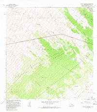
1981 Map of Kipuka Pakekake
USGS Topo · Published 1981About this map
Hawaii Volcanoes National Park dominates this terrain, revealing a complex landscape of prehistoric and historic volcanic activity on the Island of Hawaii. The map documents the Kipuka of 1880 and various other island-like remnants of older vegetation, such as Kipuka Pake Kake and Kipuka Kulalio, which were surrounded by more recent lava flows. These geological features provide a distinct contrast between the barren Ke A Poomoku and the forested corridors of the Kapapala Forest Reserve.
Find a feature on this map
24 named features on this map. Tap any name to fly to it.
Don’t see what you’re looking for? This feature index may not catch every label — zoom into the map to look around manually.
Map Details
Editions of this 1981 Kipuka Pakekake Map
2 editions found
Other maps of this area

1921 · Kilauea
USGS Topo · 1:62,500

1924 · Kilauea
USGS Topo · 1:62,500

1927 · Kaohe
USGS Topo · 1:62,500

1928 · Mauna Loa
USGS Topo · 1:62,500

1930 · Humuula
USGS Topo · 1:62,500

1930 · Kaohe
USGS Topo · 1:62,500

1954 · Hawaii South
USGS Topo · 1:250,000

1954 · Hawaii North
USGS Topo · 1:250,000
1956 · Puu Ulaula
USGS Topo · 1:24,000
1956 · Kulani
USGS Topo · 1:24,000