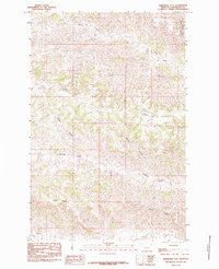
1985 Map of Kirkendal Flat
USGS Topo · Published 1985About this map
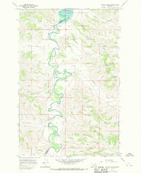
Charles M Russell National Wildlife Refuge reaches into the northeast corner of this central Montana landscape, marking a transition into protected plains and breaks. The terrain is defined by a dense network of seasonal drainage patterns, where the plateau of Kirkendal Flat gives way to deep erosional features like Gordon Coulee and Kastner Coulee. These coulees feed into more established watercourses such as Dovetail Creek and Blood Creek in the south, while Drag Creek dominates the northern reaches. The land is largely undeveloped, with Dunn Ridge forming a prominent topographical spine above the winding coulees. This 1985 provisional survey captures the area just as aerial photography began to provide more precise mapping of its complex, corrugated surface, offering a detailed view of the water-carved geography in Petroleum County.
Find a feature on this map
10 named features on this map. Tap any name to fly to it.
Don’t see what you’re looking for? This feature index may not catch every label — zoom into the map to look around manually.
Map Details
Editions of this 1985 Kirkendal Flat Map
This is the sole edition of this map. No revisions or reprints were ever made.
Other maps of this area

1954 · Jordan
USGS Topo · 1:250,000

1954 · Lewistown
USGS Topo · 1:250,000

1956 · Jordan
USGS Topo · 1:250,000

1958 · Jordan
USGS Topo · 1:250,000

1959 · Lewistown
USGS Topo · 1:250,000

1964 · Jordan
USGS Topo · 1:250,000
1965 · Germaine Coulee West
USGS Topo · 1:24,000
1965 · Weingart Place
USGS Topo · 1:24,000
1965 · Weingart Place NW
USGS Topo · 1:24,000
1967 · Nelson Coulee
USGS Topo · 1:24,000