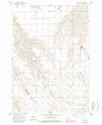
1956 Map of Kirley
USGS Topo · Published 1987About this map
Kirley serves as a central point in this mid-century survey of Haakon County, illustrating the sparse settlement patterns typical of the West River region. The landscape is dominated by expansive plateaus like Robbs Flat and Maupin Flat, which dictated the placement of early community infrastructure. Educational and spiritual life for ranching families was localized at sites such as Markwed Sch and Robbs Flat Sch, while the Deep Creek Ch stands in the southern section known as Grandfield. The hydrography of the area, defined by the West Fork Hermaphrodite Creek and the East Fork Plum Creek, shows the essential role of water management in this environment, evidenced by the Roseth Dam. These features, along with the Robbs Flat Cem, provide a detailed record of the families who established roots in this part of South Dakota.
Find a feature on this map
12 named features on this map. Tap any name to fly to it.
Don’t see what you’re looking for? This feature index may not catch every label — zoom into the map to look around manually.
Map Details
Editions of this 1956 Kirley Map
3 editions found
Other maps of this area

1954 · Pierre
USGS Topo · 1:250,000

1956 · Kirley
USGS Topo · 1:24,000

1956 · Cherry Creek NW
USGS Topo · 1:24,000

1956 · Carlin Flat
USGS Topo · 1:24,000

1956 · Alleman Station
USGS Topo · 1:24,000

1956 · Cherry Creek
USGS Topo · 1:24,000

1958 · Pierre
USGS Topo · 1:250,000

1982 · Whiteman Ranch
USGS Topo · 1:24,000

1983 · Bentley Ranch
USGS Topo · 1:24,000

1983 · Philip
USGS Topo · 1:100,000