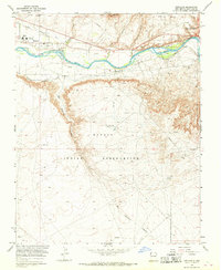
1966 Map of Kirtland
USGS Topo · Published 1969About this map
The San Juan River corridor in the mid-1960s reveals a landscape defined by the intersection of traditional irrigation and modern energy extraction. The settlement of Kirtland and the western edge of Farmington are anchored by an extensive network of water management features, including the Farmers Mutual Ditch and the Fruitland Irrigation Canal. These systems support local agriculture, while the Univ of New Mexico Experimental Farm suggests a scientific approach to high-desert land use.
Find a feature on this map
23 named features on this map. Tap any name to fly to it.
Don’t see what you’re looking for? This feature index may not catch every label — zoom into the map to look around manually.
Map Details
Editions of this 1966 Kirtland Map
2 editions found
Other maps of this area

1889 · Chaco
USGS Topo · 1:250,000

1892 · Chaco
USGS Topo · 1:250,000

1927 · Sulphur Spring
USGS Topo · 1:96,000

1928 · Kirtland
USGS Topo · 1:125,000

1932 · Kirtland
USGS Topo · 1:125,000

1954 · Shiprock
USGS Topo · 1:250,000

1958 · Shiprock
USGS Topo · 1:250,000

1959 · Shiprock
USGS Topo · 1:250,000
1963 · Farmington North
USGS Topo · 1:24,000
1963 · Youngs Lake
USGS Topo · 1:24,000