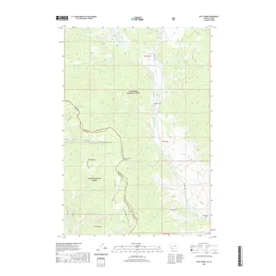
2020 Map of Kitty Creek
USGS Topo · Published 2020About this map
The Continental Divide National Scenic Trail winds through this high-altitude landscape, marking the physical boundary between Beaverhead National Forest in Montana and Salmon National Forest in Idaho. This 2020 survey reveals a complex drainage network where Bloody Dick Cr and its many tributaries, such as Lake Cr and Kitty Cr, carve through the mountainous terrain. The map captures the meeting of Beaverhead and Lemhi counties, anchored by significant topographical features like Pyramid Hill and deep valleys including Hughes Gulch and Hamilton Gulch. Grounded in the backcountry infrastructure of the era, the sheet details numerous forest routes like Bloody Dick Rd and Warm Springs Rd, along with remote water sources such as Pyatt Springs, essential for understanding the modern accessibility and conservation boundaries of this section of the Rocky Mountains.
Find a feature on this map
41 named features on this map. Tap any name to fly to it.
Don’t see what you’re looking for? This feature index may not catch every label — zoom into the map to look around manually.
Map Details
Editions of this 2020 Kitty Creek Map
This is the sole edition of this map. No revisions or reprints were ever made.
Other maps of this area

1955 · Dubois
USGS Topo · 1:250,000

1955 · Dillon
USGS Topo · 1:250,000

1956 · Goldstone Mtn
USGS Topo · 1:62,500

1956 · Lemhi
USGS Topo · 1:62,500

1957 · Dillon
USGS Topo · 1:250,000

1958 · Dubois
USGS Topo · 1:250,000

1958 · Dillon
USGS Topo · 1:250,000

1962 · Dillon
USGS Topo · 1:250,000

1965 · Dillon
USGS Topo · 1:250,000

1965 · Lemhi Pass
USGS Topo · 1:24,000