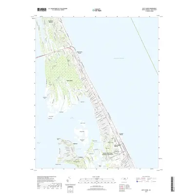
2019 Map of Kitty Hawk
USGS Topo · Published 2019About this map
The Wright Brothers National Memorial anchors the southern portion of this Outer Banks map, marking the historic grounds of the first controlled flight near Kill Devil Hill. The landscape is a complex mix of sandy barrier island terrain and intricate waterways, with Kitty Hawk Bay and Colington Creek separating the mainland-facing islands like Colington Island from the coastal dunes. Genealogical interest is found in local burial sites such as Austin Cem and Baum Cem, which predate the modern residential expansion seen in Southern Shores and Croatan Shores. The geography is defined by narrow land bridges and marshy points, including Hay Point and Shellbank Point, while First Flight Airport remains a functional nod to the area's aviation heritage. Transportation patterns show a dense network of residential loops and trails, like Poteskeet Loop and Crooked Back Loop, illustrating the contemporary development of these storied coastal communities.
Find a feature on this map
148 named features on this map. Tap any name to fly to it.
Don’t see what you’re looking for? This feature index may not catch every label — zoom into the map to look around manually.
Map Details
Editions of this 2019 Kitty Hawk Map
This is the sole edition of this map. No revisions or reprints were ever made.
Other maps of this area

1940 · Kitty Hawk
USGS Topo · 1:62,500

1940 · Powells Point
USGS Topo · 1:62,500

1943 · Roanoke Island
USGS Topo · 1:125,000

1946 · Eastville
USGS Topo · 1:250,000

1946 · Currituck Sound
USGS Topo · 1:250,000

1953 · Roanoke Island NE
USGS Topo · 1:24,000

1953 · Manteo
USGS Topo · 1:24,000

1953 · Manns Harbor
USGS Topo · 1:24,000

1955 · Wanchese
USGS Topo · 1:250,000

1957 · Manteo
USGS Topo · 1:250,000