Loading...
Loading map...1952 Map of Klamath
USGS Topo · Published 1957About this map
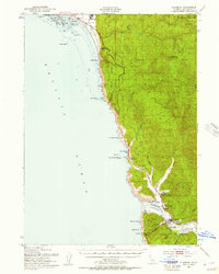
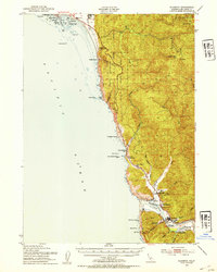
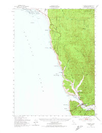
The Klamath River meets the Pacific Ocean in this mid-century survey of the Del Norte coast, where timber and tourism shaped the local economy. At the river mouth, the settlement of Requa and the nearby Requa Sch stand as established community hubs, while Camp Klamath and the Trees of Mystery along the Redwood Highway reflect the area's early development as a coastal destination. Further inland, the infrastructure of the logging industry is evident at the Veneer Mill and Mill Pond near False Klamath Cove.
Find a feature on this map
51 named features on this map. Tap any name to fly to it.
Don’t see what you’re looking for? This feature index may not catch every label — zoom into the map to look around manually.
Map Details
Date Portrayed1952
Date Published1957
PublisherU.S. Geological Survey
Map TypeTopographic
Scale1:62,500
Physical Dimensions16.7 x 20.8 inches
Editions of this 1952 Klamath Map
3 editions found
Historical Maps of Crescent City Through Time
1 maps found
Featured Locations
Source Details
SourceU.S. Geological Survey
CopyrightPublic Domain