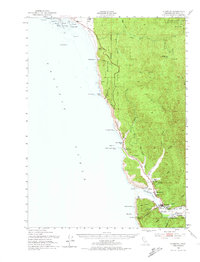
1952 Map of Klamath
USGS Topo · Published 1974About this map
Klamath River dominates the southern reaches of this mid-century survey, cutting through the Coast Indian Reservation to reach the Pacific Ocean. The local economy of the early 1950s is evidenced by industrial sites like the Veneer Mill and Sawmill near Klamath, while the Douglas Mem Bridge serves as a critical link for the Redwood Highway.
Find a feature on this map
54 named features on this map. Tap any name to fly to it.
Don’t see what you’re looking for? This feature index may not catch every label — zoom into the map to look around manually.
Map Details
Editions of this 1952 Klamath Map
3 editions found
Other maps of this area

1922 · Preston Peak
USGS Topo · 1:125,000

1925 · Hoopa
USGS Topo · 1:125,000

1929 · Crescent City
USGS Topo · 1:125,000

1945 · Ship Mountain
USGS Topo · 1:62,500

1945 · Orick
USGS Topo · 1:62,500

1945 · Gasquet
USGS Topo · 1:62,500

1945 · Point St. George
USGS Topo · 1:62,500

1945 · Requa
USGS Topo · 1:62,500

1945 · Tectah Creek
USGS Topo · 1:62,500

1948 · Weed
USGS Topo · 1:250,000