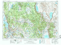
1955 Map of Klamath Falls
USGS Topo · Published 1972About this map
Klamath Falls and its surrounding high desert and mountain landscapes are captured in this mid-century survey, documenting a region defined by extensive federal lands and complex water systems. The map illustrates the sprawling boundaries of the Winema National Forest and Fremont National Forest, which surround the primary agricultural and population centers. Timber and transportation define the local economy, shown through the network of the Southern Pacific and Oregon California & Eastern railroads. Further east, the landscape transitions to the stark basins of Summer Lake and Lake Abert, flanked by the dramatic Abert Rim. Remote outposts such as Sycan Guard Station and Yamsay Guard Station provide evidence of forest management infrastructure in the backcountry. The southern portion of the sheet tracks the Klamath River and the international importance of the Upper Klamath Lake basin for regional water management and irrigation.
Find a feature on this map
105 named features on this map. Tap any name to fly to it.
Don’t see what you’re looking for? This feature index may not catch every label — zoom into the map to look around manually.
Map Details
Editions of this 1955 Klamath Falls Map
4 editions found

Other maps of this area

1886 · Alturas
USGS Topo · 1:250,000

1886 · Modoc Lava Bed
USGS Topo · 1:250,000

1886 · Shasta
USGS Topo · 1:250,000

1889 · Klamath
USGS Topo · 1:250,000

1889 · Long Valley
USGS Topo · 1:250,000

1891 · Ashland
USGS Topo · 1:250,000

1892 · Modoc Lava-Bed
USGS Topo · 1:250,000

1892 · Alturas
USGS Topo · 1:250,000

1893 · Ashland
USGS Topo · 1:250,000

1894 · Klamath
USGS Topo · 1:250,000