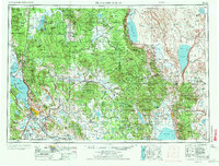
1955 Map of Klamath Falls
USGS Topo · Published 1972About this map
Upper Klamath Lake and its surrounding high-desert basins dominate this mid-century topographic perspective of Southern Oregon. The regional hub of Klamath Falls is shown alongside the neighboring communities of Altamont and Henley, with aviation activity centered at Kingsley Field. The landscape is a study in water management and natural resources, featuring the vast Sycan Marsh and the terminal waters of Summer Lake and Lake Abert.
Find a feature on this map
83 named features on this map. Tap any name to fly to it.
Don’t see what you’re looking for? This feature index may not catch every label — zoom into the map to look around manually.
Map Details
Editions of this 1955 Klamath Falls Map
4 editions found

Other maps of this area

1886 · Alturas
USGS Topo · 1:250,000

1886 · Modoc Lava Bed
USGS Topo · 1:250,000

1886 · Shasta
USGS Topo · 1:250,000

1889 · Klamath
USGS Topo · 1:250,000

1889 · Long Valley
USGS Topo · 1:250,000

1891 · Ashland
USGS Topo · 1:250,000

1892 · Modoc Lava-Bed
USGS Topo · 1:250,000

1892 · Alturas
USGS Topo · 1:250,000

1893 · Ashland
USGS Topo · 1:250,000

1894 · Klamath
USGS Topo · 1:250,000