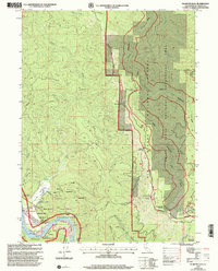
1997 Map of Klamath Glen
USGS Topo · Published 2001About this map
The Klamath River winds through the southwestern corner of this survey, defining a landscape where the Hoopa Valley Indian Reservation boundary meets the heavy timber of the Six Rivers National Forest. This 1990s revision details the hub of Klamath Glen, showing its vital riverfront infrastructure including a Boat Ramp, Fire Station, and the Klamath Station forestry office. The geography is characterized by sharp transitions from river flats like Starwein Flat to the high elevations of Rattlesnake Mountain and South Red Mountain.
Find a feature on this map
39 named features on this map. Tap any name to fly to it.
Don’t see what you’re looking for? This feature index may not catch every label — zoom into the map to look around manually.
Map Details
Editions of this 1997 Klamath Glen Map
This is the sole edition of this map. No revisions or reprints were ever made.
Other maps of this area

1922 · Preston Peak
USGS Topo · 1:125,000

1925 · Hoopa
USGS Topo · 1:125,000

1929 · Crescent City
USGS Topo · 1:125,000

1945 · Ship Mountain
USGS Topo · 1:62,500

1945 · Orick
USGS Topo · 1:62,500

1945 · Requa
USGS Topo · 1:62,500

1945 · Tectah Creek
USGS Topo · 1:62,500

1948 · Weed
USGS Topo · 1:250,000

1949 · Eureka
USGS Topo · 1:250,000

1950 · Weed
USGS Topo · 1:250,000